The Furrow and the Ridge: What Field Patterns Can Tell a Reader
Read furrow and ridge field patterns with care: see what their shape suggests, how slope affects them and which records can add useful context.
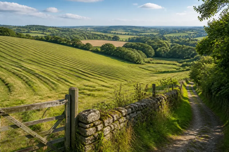
What do furrow and ridge field patterns actually tell you? They can suggest how ground was cultivated and how its shape affected the work, but a line in the soil is a clue, not a complete account of a field’s past. Notice the pattern, consider what could have made it and leave uncertain conclusions open.
Start with the whole field
A furrow is a shallow channel or trough; a ridge is the raised ground beside it. In a field with repeated, parallel ridges, first check whether the pattern continues across a broad area and relates to the slope. A few narrow lines beside a gate may be wheel marks. A regular arrangement extending across the field may be associated with cultivation, though its appearance alone cannot settle when or how it formed.
Find a position from which you can see the ridges’ direction and extent. A field edge, public path or gentle rise may offer a better view than standing among the lines. Look across rather than along them: viewing along a ridge can make its height seem more dramatic, while looking across reveals repeated shapes and spacing.
Notice where the pattern begins and ends. Does it reach the boundary, fade in the middle, bend or stop at a wet hollow? Record those details separately from your interpretation. “Parallel lines curve towards the lower corner” is an observation; “the plough followed a drainage route” is a possible explanation.
Lines that change direction
Furrows may arc, turn or seem to meet at one end rather than run neatly up and down a slope. Curved ridges can be consistent with cultivation that adapted to the field’s shape, but they may also reflect later disturbance, shifting boundaries or a change in how the ground was used. Direction alone does not identify a particular tool or period.
Check the contours around the pattern. If the ridges follow a broad curve around a slope, the land’s shape may help explain their course. If they run towards a hollow or cross a small change in gradient, local ground conditions may be relevant. Neither relationship proves a particular purpose; it helps narrow the questions to ask.
Look for places where the lines are cut or obscured. A modern gateway, track, drainage channel or boundary alteration might interrupt an older-looking pattern. The interruption can help distinguish one phase of ground use from another, but only with supporting evidence. Avoid treating every clean break as a dateable boundary.
Spacing that looks uneven
Ridges rarely appear perfectly uniform from every viewpoint. Grass, grazing, soil movement, mowing and uneven light can make neighbouring furrows seem alternately wide or shallow. Perspective adds another complication: lines farther away may look closer together, and a low sun can exaggerate one side of each ridge.
To check whether spacing varies, move your viewpoint and compare several sections of the field. Look for a repeated rhythm rather than judging one pair of lines. If a pattern is regular in one area but disturbed near a boundary, note the contrast; do not assume the disturbed part was always different.
Make a brief written record from a public place: note the direction of the ridges, where they curve, where they disappear and what lies beside them. A phone photograph can preserve the view, but a single image flattens relief and may hide shallow features. Take another view from a different angle if access and conditions allow, without entering crops or crossing private land.
When the pattern fades
Some ridges are clear only under certain light; others become hard to follow beneath grass or crop cover. A line that vanishes from view may continue under vegetation, but the visible mark may genuinely end. Do not draw a continuous feature across an unseen section simply because that would make the pattern look tidier.
Compare the feature from a different angle or in different light on a later visit. Low, slanting sunlight can make small changes in relief easier to see, while wet or freshly disturbed ground may reveal texture that grass conceals. These conditions change visibility, not the age or origin of the feature.
Say you see low ridges in a pasture, clear near the upper boundary but hard to distinguish below a grassy hollow. You note their visible direction and the point where the lines disappear, then compare the slope from a nearby public path. If the lower ground remains hidden, record the result as “visible above the hollow; uncertain below it”, rather than claiming the ridges continue across the field.
Clues and conclusions?
Do parallel ridges prove that a field was ploughed?
Repeated ridges may be consistent with cultivation, especially when they form a coherent pattern across the ground. They do not establish which implement was used, when the work occurred or whether every visible line has the same origin.
Can ridge direction reveal how the land was used?
Consider direction alongside slope, field shape and nearby boundaries. It may suggest that cultivation responded to the ground, but cannot identify a crop or a specific farming practice on its own.
Are the largest ridges the oldest?
Visible height is not a reliable age guide by itself. Soil movement, vegetation, later cultivation and viewing angle can all affect how pronounced a ridge appears.
Where can I check a suspected historic pattern?
Compare your observations with local historic maps, aerial imagery, parish records or information from a county or local heritage service. These sources may add context, but coverage and detail vary, so keep direct observation distinct from what a record suggests.
When ground shape misleads
A field’s natural contours can resemble repeated ridges, particularly where the slope is gentle or the view is distant. Conversely, cultivation lines may follow natural bends closely enough to look like one broad landform. Check whether you can trace several comparable, repeated units, rather than relying on a single raised line.
Look for changes in the pattern across the field. If similar ridges recur at a steady angle and spacing, that repetition supports the possibility that human activity shaped them. If one broad rise continues without matching parallel troughs, natural relief may be a better starting explanation. Mixed causes are possible: people worked on ground that already had a shape.
Do not walk onto a ridge to test its height or scrape away vegetation to find its edges. Besides risking damage or conflict with land users, close inspection can make a shallow feature harder to understand as a whole. From an appropriate path or field edge, a careful sketch of direction, curvature and interruptions is usually more useful than an isolated close-up.
What other evidence adds
Once you have described what is visible, compare it with other evidence. Historic maps may show earlier field divisions or land uses; aerial images can reveal patterns that are difficult to see from ground level; local heritage records may note known earthworks. Each source answers different questions, and none automatically explains every ridge in a present-day field.
Check that a map or image covers the same place and that you can match its boundaries to features you recognise. A boundary that has since moved can make a pattern seem misplaced. If sources disagree, keep both observations in your notes rather than forcing them into a single story. A local authority heritage team or knowledgeable local group may help identify suitable records; ask before treating a tentative identification as established fact.
Trying to infer a precise date, crop or ploughing method from ridge shape alone is not worth the effort. Those claims require evidence beyond the surface pattern. A more useful question is what the feature’s course, repetition and relationship to the terrain make plausible, and what remains unknown.
Keep the reading measured
A good field note separates three things: what you can see, what might explain it and what evidence would help decide between explanations. For example, write “parallel ridges curve towards the lower boundary” before adding “possibly shaped by cultivation following the slope”. This keeps the observation clear without making it carry more than it can support.
Read furrow and ridge field patterns as traces of work meeting landform, not as captions that tell a complete story. Notice repetition, direction, interruptions and visibility, then check maps or local records where a stronger claim matters. The most useful interpretation is often the one that shows exactly where the visible evidence ends.